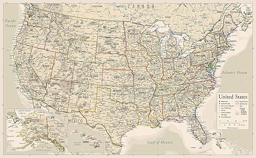
Antique Style USA Map - Wall Chart Map of The United States of America - Made in The USA - Updated (LAMINATED, 18" x 29")
Desde $ 26.944 /mes
Total: $ 107.777
Marca
Lighthouse Geographics
Categoría
MapsTiempo de entrega estimada Sábado 25 de abril al Viernes 1 de mayo.
Precio y formas de pago
4 partes mensuales sin intereses
4 pagos de
$ 27.444
/ mesAliados para comprar ahora y pagar después
Compra segura
Protección total en tu pago y tu pedido.
Cuotas flexibles
Elige entre pago único o hasta 4 partes.
Envío verificado
Cobertura nacional con seguimiento en cada etapa.
Tiempo de entrega estimada Sábado 25 de abril al Viernes 1 de mayo.
Compras Empresariales — Maps
Solicite una cotización para su empresa
Geography de la marca Lighthouse Geographics con del papel 18 inches x 26 inches
Desde $ 26.944 /mes
Total: $ 107.777
Desde $ 110.694 /mes
Total: $ 442.777

Desde $ 168.694 /mes
Total: $ 674.777

Desde $ 43.944 /mes
Total: $ 175.777
Desde $ 62.944 /mes
Total: $ 251.777

Desde $ 28.694 /mes
Total: $ 114.777

Desde $ 504.694 /mes
Total: $ 2.018.777
Geography de la marca Lighthouse Geographics con del papel 18 inches x 26 inches
¿De qué marca es?
Lighthouse Geographics.
¿Qué color tiene?
varios tonos.
¿Cuánto pesa?
1,0 libras, aproximadamente 0,5 kg.
¿Cuáles son sus dimensiones?
17 x 26 x 0.01 pulgadas, aproximadamente 43.2 x 66.0 x 0.0 cm.
| Campo | Valor |
|---|---|
| Tipo | Papel Tamaño del papel 18 inches x 26 inches |
| Acabado | del papel Revestido |
| SKU | B07PX3Q42F |
| Modelo | 42010 |
UNITED STATES MAP: This map features the continental United States (USA) with clear inserts for Hawaii and Alaska all in clear and lively pastel colors showing the state names and their capitals. The map presents the most current geographical and cartographical data available. MAP FOR KIDS: This map is designed in a minimalist manner to offer kids and young students a basic and clear display of the US states and their capitals. DURABLE LAMINATION: Most map sellers habitually and inaccurately reference lamination when in fact they use only paper that is UV-coated. This map has thick, double-sided real lamination, providing protection and durability. SIZE AND SHIPPING: The exact measurements of the laminated map are 26” x 17 ¾”. The map is rolled up into a plastic sleeve and shipped in a tube. MADE IN USA: The designs, printing, and lamination are all done in the United States
ASIN B07PX3Q42F Opinión media de los clientes 4.6 4.6 de 5 estrellas 437 calificaciones 4.6 de 5 estrellas Clasificación en los más vendidos de Yaxa nº149,190 en Productos de Oficina (Ver el Top 100 en Productos de Oficina) nº439 en Mapas Educativos Producto en Tienda desde marzo 26, 2019
Valoraciones
455