¡Lanzamiento Especial!
Descubre nuestra tienda especializada en productos importados de China.
VisÃtanos en: importadosdechina.yaxa.co
Descripción
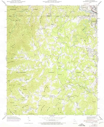
USGS topographic map of Epworth, Georgia, dated 1941, updated 1975.Includes geographic coordinates (latitude and longitude), lines of elevation, bodies of water, roads, and more. This topo quad is suitable for recreational, outdoor uses, office applications, or wall map framing.Printed on-demand by YellowMaps on the print material of your choice.Shipping rolled from Minneapolis, MN, United States.Product Number: USGS-5361700Map Size: 26.9 inches high x 22.1 inches wideMap Scale: 1:24000Map Type: POD USGS Topographic MapMap Series: HTMCMap Version: HistoricalCell ID: 14471Scan ID: 245660Imprint Year: 1975Woodland Tint: YesPhoto Revision Year: 1973Aerial Photo Year: 1973Datum: NAD27Map Projection: PolyconicMap published by Tennessee Valley AuthorityMap Language: EnglishScanner Resolution: 600 dpiMap Cell Name: EpworthGrid size: 7.5 X 7.5 MinuteDate on map: 1941Geographical region: Georgia, United StatesNorthern map edge Latitude: 35°Southern map edge Latitude: 34.875°Western map edge Longitude: -84.5°Eastern map edge Longitude: -84.375°Surrounding map sheets (copy & paste the Product No. in the search bar):North: USGS-5659472,USGS-5333980,USGS-5337016,USGS-5333982,USGS-5339092East: USGS-5363042,USGS-5363036,USGS-5363044,USGS-5363040,USGS-5363046South: USGS-5360988,USGS-5360984,USGS-5360990,USGS-5360994,USGS-5360986West: USGS-5362138,USGS-5362140,USGS-5362142,USGS-5362144,USGS-5362146
CaracterÃsticas
Printed on Regular Paper (32lb) USGS topographic map of Epworth, GA, at 1:24000 scale. High-quality paper print. Perfect for wall maps. Cities, towns, villages: Patterson Mill,Kingtown,Chestnut Gap,Staffordtown,Dunn,Lickskillet,Galloway Mill,Jonestown,Madola,Fry,Oasis,Pierceville,Epworth,Colwell,Higdon Rivers, creeks: Pack Creek,Kingtown Branch,McClure Creek,Watson Creek,Callahan Branch,Five Mile Cove Branch,Higdon Creek,Davis Mill Creek,Grusher Branch,Little Fightingtown Creek,Fightingtown Creek,Buck Creek,Patterson Creek,Dunn Creek,Madola Mill Creek,Silvermine Creek,Sholer Branch,Ritchie Creek Lakes: Consult topo map preview for bodies of fresh water.
Peso
57.00 Gramos
Dimensiones
22.1 x 26.9 pulgadas
Fabricante es ‎USGS
Destacados
Printed on Regular Paper (32lb), USGS topographic map of Epworth, GA, at 1:24000 scale. High-quality paper print. Perfect for wall maps., Cities, towns, villages: Patterson Mill,Kingtown,Chestnut Gap,Staffordtown,Dunn,Lickskillet,Galloway Mill,Jonestown,Madola,Fry,Oasis,Pierceville,Epworth,Colwell,Higdon, Rivers, creeks: Pack Creek,Kingtown Branch,McClure Creek,Watson Creek,Callahan Branch,Five Mile Cove Branch,Higdon Creek,Davis Mill Creek,Grusher Branch,Little Fightingtown Creek,Fightingtown Creek,Buck Creek,Patterson Creek,Dunn Creek,Madola Mill Creek,Silvermine Creek,Sholer Branch,Ritchie Creek, Lakes: Consult topo map preview for bodies of fresh water.
Valoraciones
No hay reseñas todavÃa