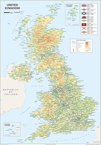
Explore the rich geography and cultural heritage of the United Kingdom with this detailed physical map. Covering England, Scotland, Wales, and Northern Ireland, it highlights the country's diverse terrain, from rugged highlands and rolling hills to bustling cities and historic coastlines. Clearly labeled features include capital cities, rivers, major roads, towns, and surrounding bodies of water. Vivid colors and sharp text make it both visually striking and easy to read—an excellent reference for anyone looking to understand the landscape of this influential island nation. Includes key locations such as London, Edinburgh, Cardiff, and Belfast Features natural and political elements: rivers, mountains, road networks, and borders Ideal for educational settings, home decor, or professional spaces Printed on high-quality paper and laminated with a durable gloss finish Whether you're tracing ancestral roots, planning travel, or studying European geography, this map brings the United Kingdom’s character and topography to life.
ASIN B09YRWDWN5 Opinión media de los clientes 4.3 4.3 de 5 estrellas 15 calificaciones 4.3 de 5 estrellas Clasificación en los más vendidos de Amazon nº284,218 en Productos de Oficina (Ver el Top 100 en Productos de Oficina) nº1,009 en Mapas Educativos Producto en Tienda desde abril 25, 2022