$446,777

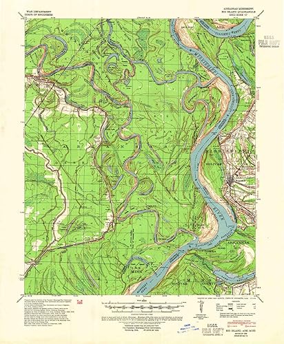
YellowMaps Big Island AR topo map, 162500 Scale, 15 X 15 Minute, Historical, 1939, Updated 1966, 21.8 x 16.9 in

Disponibilidad: Hay existencias

Pago seguro con

Ventajas de Comprar en Yaxa

  • Envío GRATUITO
  • Pagos seguros - La pasarela es la que procesa y almacena tu pago
  • Compras Empresariales - Se entrega Factura Electrónica
  • Compra Internacional
  • Tiempo de entrega de 7 a 15 días hábiles

Printed on Polypropylene (plastic), USGS topographic map of Big Island, AR, at 1:62500 scale. Heavier material. Waterproof. Tear-resistant. Foldable. Perfect for the outdoors., Cities, towns, villages: Beulah Island Landing,Lacy (historical),Medina,Terrene Landing,Rosedale,White River,Riverton Landing,Benzal,Yancopin,Wargo Landing, Islands: Montgomery Towhead,Chute of Island Number 73,Beulah Island Number 74,Ozark Island Number Seventyfive,Concordia Island, Parks and forests: Walter Sillers Memorial Park,Trusten Holder State Wildlife Management Area,Menard-Hodges Site

SKU: B07L2HLQ93 Categoría:

Descripción

Descripción
USGS topographic map of Big Island, Arkansas, dated 1939, updated 1966.Includes geographic coordinates (latitude and longitude), lines of elevation, bodies of water, roads, and more. This topo quad is suitable for recreational, outdoor uses, office applications, or wall map framing.Printed on-demand by YellowMaps on the print material of your choice.Shipping rolled from Minneapolis, MN, United States.Product Number: USGS-5429134Map Size: 21.8 inches high x 16.9 inches wideMap Scale: 1:62500Map Type: POD USGS Topographic MapMap Series: HTMCMap Version: HistoricalCell ID: 51362Scan ID: 259998Imprint Year: 1966Woodland Tint: YesDatum: NADMap Projection: PolyconicMap published by United States Army Corps of EngineersMap published by United States Department of WarMap Language: EnglishScanner Resolution: 600 dpiMap Cell Name: Big IslandGrid size: 15 X 15 MinuteDate on map: 1939Geographical region: Arkansas, United StatesNorthern map edge Latitude: 34°Southern map edge Latitude: 33.75°Western map edge Longitude: -91.25°Eastern map edge Longitude: -91°Surrounding map sheets (copy & paste the Product No. in the search bar):North: USGS-5429294,USGS-5426692,USGS-5429292,USGS-5429296,USGS-5426690East: USGS-5598660,USGS-5595416,USGS-5598656,USGS-5598658South: USGS-5429366,USGS-5598508,USGS-5429368,USGS-5598510,USGS-5425588West: USGS-5429572,USGS-5426960,USGS-5429200,USGS-5429574
Características
Printed on Polypropylene (plastic) USGS topographic map of Big Island, AR, at 1:62500 scale. Heavier material. Waterproof. Tear-resistant. Foldable. Perfect for the outdoors. Cities, towns, villages: Beulah Island Landing,Lacy (historical),Medina,Terrene Landing,Rosedale,White River,Riverton Landing,Benzal,Yancopin,Wargo Landing Islands: Montgomery Towhead,Chute of Island Number 73,Beulah Island Number 74,Ozark Island Number Seventyfive,Concordia Island Parks and forests: Walter Sillers Memorial Park,Trusten Holder State Wildlife Management Area,Menard-Hodges Site
Peso
64.00 Gramos
Dimensiones
16.9 x 21.8 pulgadas
Fabricante es ‎USGS
Destacados
Printed on Polypropylene (plastic), USGS topographic map of Big Island, AR, at 1:62500 scale. Heavier material. Waterproof. Tear-resistant. Foldable. Perfect for the outdoors., Cities, towns, villages: Beulah Island Landing,Lacy (historical),Medina,Terrene Landing,Rosedale,White River,Riverton Landing,Benzal,Yancopin,Wargo Landing, Islands: Montgomery Towhead,Chute of Island Number 73,Beulah Island Number 74,Ozark Island Number Seventyfive,Concordia Island, Parks and forests: Walter Sillers Memorial Park,Trusten Holder State Wildlife Management Area,Menard-Hodges Site

Información adicional

Peso 1.00 lbs

Valoraciones (0)

Valoraciones

No hay reseñas todavía

Solo los usuarios registrados que hayan comprado este producto pueden hacer una valoración.

Carrito de compra
YellowMaps Big Island AR topo map, 162500 Scale, 15 X 15 Minute, Historical, 1939, Updated 1966, 21.8 x 16.9 in ColombiaYellowMaps Big Island AR topo map, 162500 Scale, 15 X 15 Minute, Historical, 1939, Updated 1966, 21.8 x 16.9 in
$446,777

Disponibilidad: Hay existencias

Abrir chat
1
💬 ¿Te ayudamos?
Yaxachat
¡Este producto puede ser tuyo solo por $446,777!
Si tienes alguna duda adicional, pregúntanos.